|
 |
|

Beginnings:
This software tool is the result of a research effort begun in 1998 among APL-UW, the University of Massachusetts Distributed Artificial Intelligence Laboratory, the University of Hawaii, and GuideNet, Inc., a small Honolulu Internet company. Funding came from CEROS/DARPA (National Defense Center of Excellence for Research in Ocean Sciences/Defense Advanced Research Projects Agency). The High Seas Warning (HSW) prototype, now known as MAWS, is currently in use at the Naval Pacific Meteorological and Oceanographic CENTER (NPMOC) in San Diego under the support of SPAWAR PMW-185 (now 155), which also helped fund the project. There are plans to set up MAWS in Norfolk in the summer of 2002.
|
|
|
|
|
|
Today:
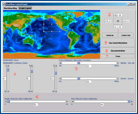
MAWS is a Web-based system that automates the retrieval of information resources needed to produce a high seas warning. MAWS includes a GUI, an inference engine that controls the workflow, and an interactive, geospatial mapping component. MAWS verifies data from disparate sources. The various data requests can include wave height, wind velocity, precipitation, geolocation, etc. The verification of a combined seas warning occurs through the use of: 1) numerical model forecasts, 2) satellite altimetry swaths, 3) ship or buoy observations, and 4) other observations available on the Web. The data values from all these different sources are then compared in the same location.
An automated workflow system merges model output and observations into a composite, high seas analysis. The forecaster uses this to evaluate future areas that could have seas greater than the critical value of interest. Through the user interface an operator can confirm or modify the automatically generated forecast.
The high seas warnings are created with a Navy computer program called WARNGEN and output is in text, graphic and raw data values from Web sites such as JTWC, Pearl Harbor, or NPMOC, San Diego.
MAWS' Java Language implementation allows seamless client/server workflow management using WBStart/servlets and a sophisticated geospatial information management system. This automated tool has allowed the Navy to reduce significantly the time it takes to produce forecasts since the data can be retrieved in minutes and forecasts can be completed within 20-30 minutes.
|
|
|
|
Background:
Prior to this automated capability, Navy forecasters had to produce the high seas analysis by hand. They employed two or three computers and a series of transparent overlays. They used grease pencils and seat-of-the-pants ingenuity, which could be correct depending upon their level of experience. This involved process took two to three hours to perform and left lots of room for error.
|
|
|